(Click here to download a printable version of this article)
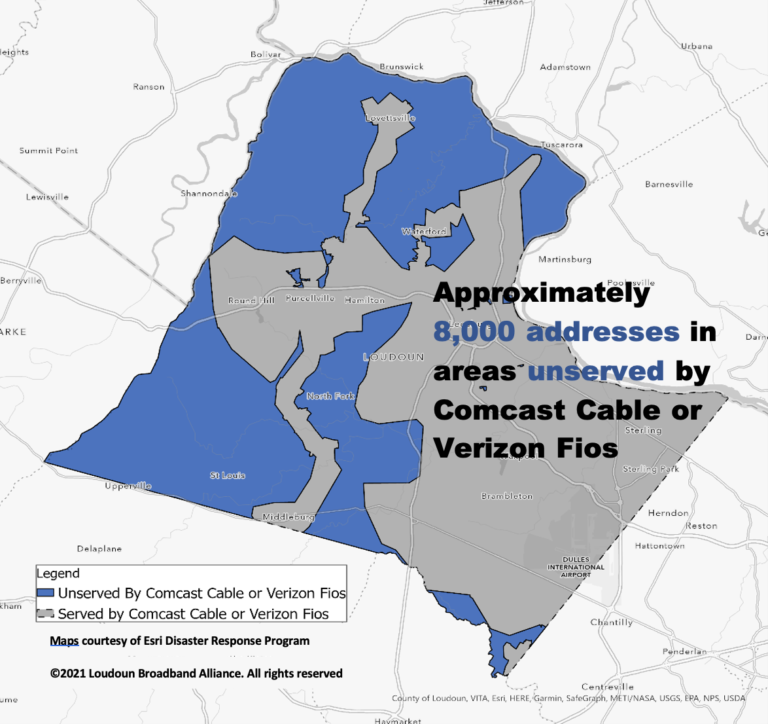
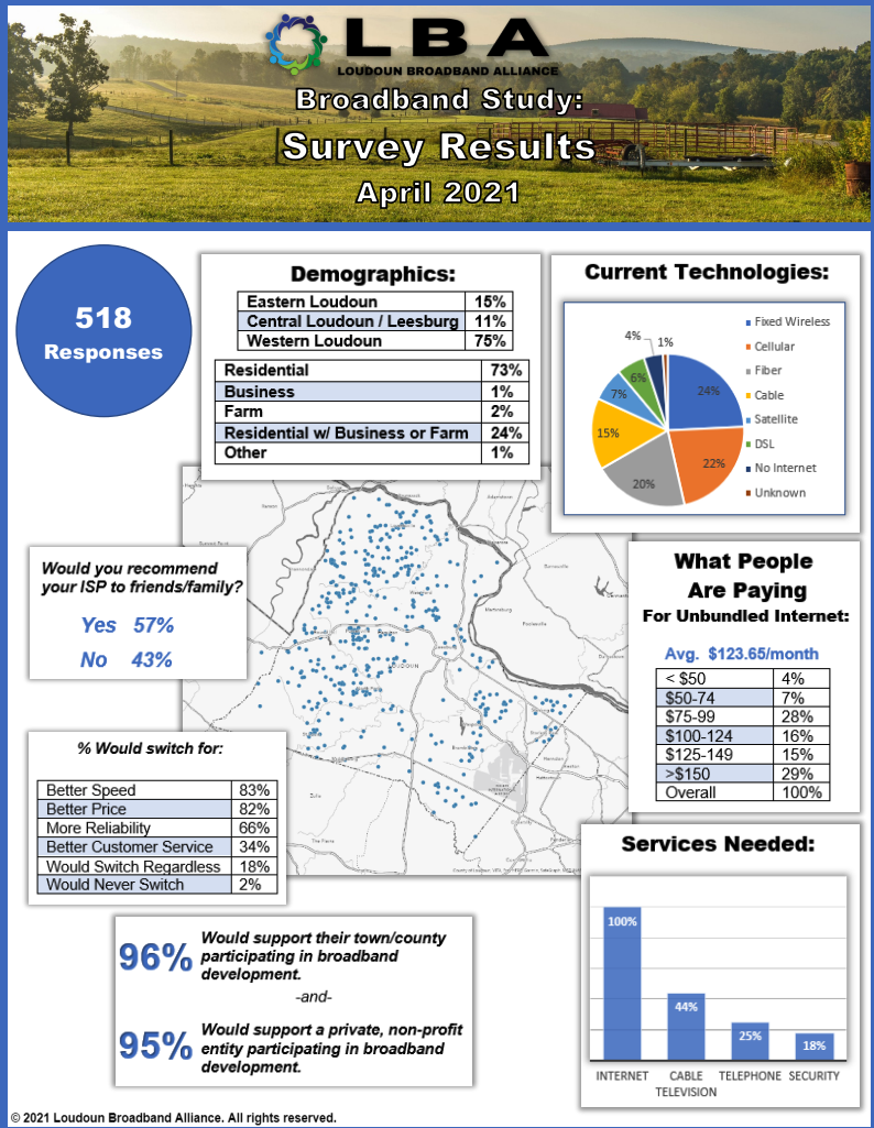
Loudoun Broadband Alliance (LBA) recently conducted an internet access survey for residents and businesses in the county. The short survey, which was open for approximately 30 days (between February and March), collected responses to better understand the needs and desires of respondents regarding existing and future Internet services. The goal of this study is to generate updated maps that identify areas in Loudoun County that are unserved by broadband Internet access.
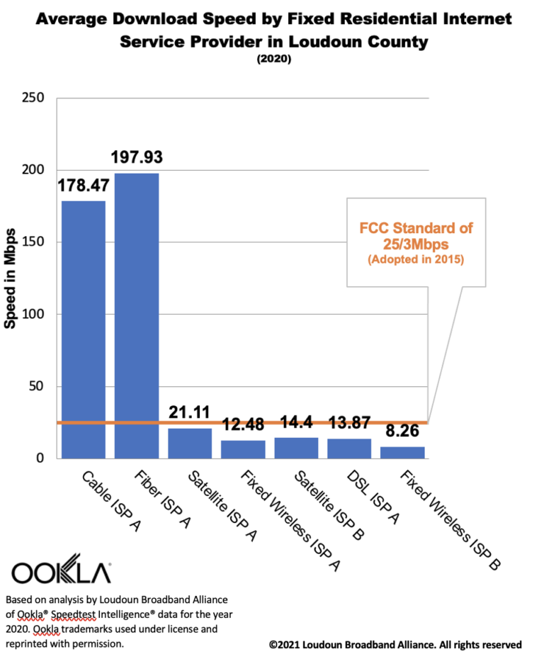
Also used in the study, are the results of hundreds of thousands of user-initiated tests performed across all of Loudoun County during the year 2020. The results of these tests were provided to LBA under a pilot program with Ookla®.
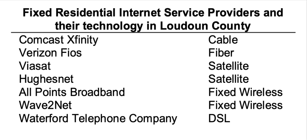
LBA analyzed survey responses and Ookla® Speedtest® data to compare performance of Internet services in different areas of the county. LBA overlaid these data with currently available provider maps. Associating the providers and technologies available in each part of the county and comparing the speeds available in each, LBA observed that the areas not served by fiber or cable fell below the FCC’s standard of broadband (25Mbps download/3Mbps upload) and, therefore, are identified as unserved.


LBA believes this map to be the most accurate representation, as of the date of this report, of the need for broadband in Loudoun County and acknowledges that this map can and must be refined through additional study and analysis. LBA, in alignment with its mission, will continue its research and hopes to provide more accurate mapping and information in the near future.
Survey Results
Along with this updated map, LBA also released the results of our survey that ran during February and March of 2021.

How we created the map
LBA used maps provided by the franchisees to Loudoun County as the starting point for this study, hypothesizing that only those areas are served by Internet with speeds that meet the FCC’s definition of broadband Internet – 25Mbps download and 3 Mbps upload.
LBA then used data available through our pilot program with Ookla to compare Internet speeds available in the areas served by the franchisee versus speeds available from Internet service providers in the areas not served by the franchisees.
This comparison confirmed our hypothesis.
LBA then used public records to count the number of addresses located inside the areas not served by the franchisees. LBA recognizes that this number, 8254, is not completely accurate. The biggest error is due to the age of the maps supplied by the franchisees. Since those maps were created, the franchisees have extended service to a few new locations. In addition, new homes have been built since the maps were published. Further, the maps supplied by the franchisees overstate their coverage areas.
LBA is processing additional data available from multiple sources so that this map can be refined. If you would like to contribute corrections to the map, please contact us and provide us with your address.